 Clive's
UndergrounD Line Guides
Clive's
UndergrounD Line Guides
Clive's
UndergrounD Line Guides
Clive's
UndergrounD Line Guides
"If it were not so, the most poetical thing in the world would be the Underground Railway."
- The Man Who Was Thursday
G.K. Chesterton
"The London Underground is not a political movement."
- A Fish Called Wanda
John Cleese
IntroductionClive's UndergrounD Line Guides are a series of web pages describing the London Underground system. It includes all routes which have been under the control of London Underground Limited or its predecessors at one time or another; see below for a more detailed discussion of the coverage. Each line is covered on a single page, mostly in the same general format. There is a glossary of abbreviations later on this page.
These guides are written by and copyright to Clive D.W. Feather. I can be emailed at <clive@davros.org>. Private copies may be made of the guides, and links may be made to them, without restriction. They, or extracts or modified forms, are not to be published in any medium without my explicit permission, except for short extracts under the "fair dealing" provisions, and all other rights are reserved.
These guides are not in the "public domain", nor are they issued under any Creative Commons or similar licence.
I am not associated with the rail operators mentioned herein, particularly LU, in any way other than being a (usually) satisfied customer of their services.
The basic rule for deciding what is covered is "has it been used by London Underground or one of its predecessors?". However, this doesn't always produce satisfactory (to me) results.
I have tried to handle the marginal cases with a mix of consistency and clarity. For example, the North London Line from Richmond to North Woolwich is omitted, because its only link with LU (apart from the short part used by the District Line and the longer part taken over by the DLR) is that it appears on the Underground Map. On the other hand, all the platforms at Upminster are shown, even though the District Line only uses a few of them, because it is a single station. The National Rail line to Watford Junction is shown because the Bakerloo used to use it, and the Elizabeth Line is included because it's a tube line that's operated by Transport for London even if the tunnels are bigger and the trains are full size. In contrast, the Thameslink route through Blackfriars is omitted south of its connection at Farringdon because it does not, and never has, carried "Underground" trains. (At the end of the day, though, it's my decision even if others think I'm being inconsistent.)
Routes that were planned but never used, such as the Central Line to Denham, are normally omitted. However, an exception has been made for the Northern Line, where the Northern Heights extension was largely completed and then abandoned, both because of this and because many of the details were hard to locate elsewhere when I first added it. Similarly, while planned changes and extensions may be mentioned in the descriptive sections, details are normally only given when work on construction has actually started (but there is a separate page on future proposals).
Several sections of route have been transferred from one line to another. In this case, the detailed information may be given on both pages or may be given only on the page for which it is more relevant, with just a link on the other page. Similarly lines have merged or been split up over the years; in general, a separate page is provided for each line that currently has a separate identity or had one in recent years. So the Hammersmith & City and East London Lines are separate from the Metropolitan Line, even though they used to be part of it, whereas the three companies that formed the Northern Line are not distinguished from each other.
All known line and station openings are shown, even if they only lasted a day or two. Temporary closures are mostly only shown if they lasted at least a week, though exceptions are made where I consider them interesting. Sometimes trains on one line ran on to another line for short periods for some reason. These are not generally treated as openings followed by closure of a new section of line but, rather, are mentioned in the Services section of the page under the heading "Special services". The choice of treatment of such services is based on my understanding of whether they were intended to be temporary or permanent.
Each page contains a detailed history of that line and describes specific features (a detailed discussion of the page layout is below). However, a number of common matters are discussed here.
Though the Underground is often called "the Tube", strictly speaking this name should only be used for part of the system. A tube line is one that, when underground, mostly uses bored tunnels that are circular (or almost so), with each track in a separate tunnel (except at junctions and some stations). Generally these are relatively deep, well below the level of existing subsurface works. Since increasing the tunnel size increases construction costs, tube tunnels are made as small as practical in the circumstances; mostly (though not always) both tunnels and trains are much smaller than other railways.
The earliest underground lines were created in the 19th century, starting in 1863. They were all built to the main-line standards of the era. In the central area they were put underground by digging a trench in a road and then roofing it over: the "cut-and-cover" method. These "subsurface" lines ran full-sized trains; initially they used steam locomotives designed or modified to condense their own steam instead of releasing it, but in 1905 all the subsurface lines were electrified apart from some outlying (open-air) portions. The first such line - the Metropolitan Railway - came to control many of the others, and it remained independent until 1933.
Between 1890 and 1904 four proposals for underground railways in London came to fruition; three were developed independently, while one was a project of the LSWR and remained owned by it and its successors until 1994. Three major changes in circumstances had taken place since the building of the subsurface lines: electric trains were now practical, increasing costs made it impractical to dig up roads, and the Greathead shield - a practical tunnelling method - had been invented. The result was that all these lines were tube lines operated from the outset with electric traction.
In the same time period five other tube line proposals were approved but ran into financial problems. All were acquired by the American financier Charles Yerkes and became part of his Underground Electric Railways Company of London Limited (which was formed 1902-04-09 and had already taken over the subsurface District Line), in turn part of the "Yerkes group" (which also included other forms of transport). All these lines - sometimes known as "the Yerkes tubes" - opened in 1906 or 1907. In 1913 the group would also acquire two of the independent tube lines while the Metropolitan Railway gained the third. Yerkes is distinguished by having a crater on the moon named after him - a 36 km diameter crater just inside the western edge of the Mare Crisium. However, this is for his funding of an observatory, not his effects on transport in London.
In 1933 the Yerkes group and the Metropolitan Railway were absorbed into the London Passenger Transport Board. This was a hybrid body: it had shareholders who received dividends, but they had no control over the company. Instead its board was appointed by representatives of London's banking, accounting, and legal communities, its traffic advisory committee, and the county council. The network was then nationalized in 1948.
While many extensions and modifications to the system happened, no new lines had been built in Central London since 1907. This changed in the 1960s with the first state-built tube line, the Victoria Line, followed in 1979 by the Jubilee Line (which was greatly extended in the late 1990s) and then in 2022 by the Elizabeth Line.
The 1980s saw a new approach to transport in London: the use of light railways built at low cost, often by reusing existing or former infrastructure. Two of these have been built so far: the Docklands Light Railway and Croydon Tramlink (which is a true tram system including on-street running). As well as further tram proposals, there are suggestions for trolleybuses to return to London.
In 2002 the ownership of the LU system was split into three separate companies: "Infraco subsurface", "Infraco BCV" (including the Waterloo & City Line), and "Infraco JNP". In 2003 each of these was franchised to a private sector consortium, which became responsible for maintenance and renewals while services continue to be run by LU. However, in 2008 the franchisee operating the first two failed and they were taken back into public ownership, and in 2010 LU bought the third ("Infraco JNP") from its owners.
All Underground lines use the standard gauge of 1435mm (4'8½") (see also "Measurements" below) between the inner edges of the rails; where this was previously different it is mentioned on the relevant page. [As there is a small amount of tolerance in the rail position, as assorted adjustments have been tried at times to improve running or reduce noise, and as the measurement has variously been taken from the inner edges of the rails, the mid-lines of the rails, or cited in terms of the wheel flanges, a range of nearby values - such as 1432mm and 4'8¼" - will also be seen.]
For legal reasons, the older tube lines were built almost entirely under roads, even when sharp curves or other awkward layouts were required. The modern tubes, which were Government projects, are not so restricted. Wherever possible, tube lines are dug within the thick layer of blue clay that lies under much of London and which is ideal tunnelling material.
The Yerkes tubes were all built to a common standard: the tunnel diameter is 3.56 m (11'8¼"), and the track was electrified from the outset using the Yerkes system of electrification, which had just been applied to the subsurface lines. In contrast, each of the early independent tube lines used its own electrical system and chose its own tunnel size. All were eventually brought into effective conformance with the Yerkes standards. Two of the modern tubes (Victoria Line and Jubilee Line) are built to the same basic standards as the Yerkes tubes, but the nominal diameter has been increased to 3.66m (12'0") or more to reduce air resistance, with the actual diameter typically between 3.71m (12'2") and 3.86m (12'8"). The Battersea extension of the Northern Line has one-metre-wide walkways in the tunnels, which are therefore 5.2m (17'1") in diameter. In each case, "diameter" is that of the largest cylinder that would fit in the tunnels; normally this would be one just touching the flanges of the lining pieces. The 8¼" in the Yerkes standard diameter comes from a late trimming of the flanges from an original design of 11'6". The Elizabeth Line and the GN&CR part of the Northern Line are tubes built to take full-size trains.
The Docklands Light Railway was built in the 1980s and 1990s as a light railway (little more substantial than a tramway). Tramlink in Croydon is a mixture of light railway on existing infrastructure and traditional on- and off-street tramway.
The Yerkes system of electrification, which became the LU standard, involves two power rails separate from the running rails (hence the term "fourth rail"). The positive rail is placed outside one of the running rails, its surface 75 mm (3") above them and its centre line 406±10 mm (16") outside the inner edge of the running rail. The negative rail is placed centrally between the running rails and its surface is 4 cm (1½") above them. The nominal voltages are +420 V and -210 V for a total of 630 V supplied to the train (the voltages are maintained by using 200 ohm and 100 ohm "bleed" (or "ballast") resistors at the substation to connect the power and running rails). [It should be noted that the voltages probably vary across the network and have certainly varied over the years. Some sources describe the nominal voltages as +440 V, -220 V, and 660 V, and the bleed resistances are also sometimes quoted as 400 ohms and 200 ohms. The experimental section between Acton Town and South Harrow used +550 V with the negative rail earthed. The system actually adopted in 1905 used 600 V, being increased to 630 V in the 1930s.]
Work is in progress to raise the voltage on the subsurface lines to 750 V (with a +500 V / -250 V arrangement). The sections completed so far are:
| 2016-03 | Hammersmith (1) to Bouverie Place |
| 2016-10 | Moorgate and Tower Hill to Whitechapel (including Aldgate) |
| 2017-06 | Harrow-on-the-Hill to Amersham, Chesham, and Watford |
| 2017-06 | Upney to Upminster |
| 2017-06 | Whitechapel to Upney |
| 2017-10 | Baker Street to Finchley Road |
| 2017-10 | Notting Hill Gate via Baker Street to Moorgate |
| 2017-10 | Barons Court, Putney Bridge, and Olympia to Victoria and Notting Hill Gate including South Kensington to High Street Kensington |
When the Piccadilly Line gets new rolling stock, it will be converted as well.
The 4-rail system has a number of advantages compared with the more common 3-rail one. For example, it reduces corrosion from galvanic action (particularly corrosion of the iron tunnel linings), is more tolerant of faults (an earth fault on one power rail has no effect on the service), and simplifies both the signalling and other features (replacement of running rails does not affect the power supply and there is no need for electrical bonds on them).
There are some surface lines where both LU trains and those designed for the National Rail 3-rail system run. That system has a positive rail in the same position but uses earthed running rails for return. On these shared sections the negative rail is earthed with the positive rail held at the full voltage (e.g. +630 V); both types of train thus receive the correct power supply (albeit not necessarily at the preferred voltage). Various arrangements have been used to handle the transition between the two systems, including resistances and switchable sections, but now that no LU trains have power lines between cars, a gap of about 20 m suffices. In the case of the Bakerloo north of Queen's Park, the District between Gunnersbury and Richmond, and the East London Line north of Shoreditch High Street, the lines were originally electrified on the four-rail system and then converted to the above arrangement with effect from 1970-08-02.
The Docklands Light Railway uses a bottom contact third rail, while Tramlink uses overhead catenary; in each case these are at +750 V, with return through the running rails.
The Elizabeth Line uses 25 kV overhead AC power with catenary wire in open areas and rigid contact bars in the central tunnels to reduce the size of tunnel required (catenary wire needs more room above the train for the wire supports).
At the time the first Underground lines were being constructed, main line railways typically operated three classes of accommodation (1st, 2nd, and 3rd). Since they saw themselves as just another railway, the Metropolitan and MDR followed suit. Starting in 1875, some main line companies decided to abolish second class. The MDR abolished it on each route as it was electrified. The last day of provision on the Metropolitan north of Baker Street was 1905-01-31; it is believed that on the remaining sections it also went with electrification.
The deep-level tubes, on the other hand, were simply interested in moving as many people as possible and didn't normally have ticket inspections on the train. They therefore generally operated with a single class of seat (the sole exception being the GN&CR).
First class was generally abolished after the move to state operation. The last day of provision was 1934-03-24 on the GN&CR, 1936-05-03 on the Hammersmith & City, 1940-01-31 on most other lines, and finally 1941-10-05 on the Metropolitan Line services running north of Moor Park.
Telegraphic addresses were (rented) abbreviations or codewords used when sending telegrams. They were popular because telegrams were charged by the word, including the destination so, for example, the "address" UNDERNEATH LONDON is easier to remember, shorter to write, and cheaper to send than 55 BROADWAY LONDON.
Several of the companies that became part of the Underground also had their own telegraphic addresses, as listed in the following table (the LONDON suffix is omitted); where more than one is given, they are in chronological order of use.
| Baker Street & Waterloo Railway | OUTNOISE, UNDERSOIL |
| Central London Railway | RHEOMOTOR |
| City & South London Railway | TUNNELLING |
| Great Northern & City Railway | RESUMPTION, RAPIDNESS |
| Metropolitan District Railway | CIRCUMITION, ZONEDIST, DISELECT |
| Metropolitan Railway | METELECTRO, UNDERGROUND, METELECTRIC UPBAKER |
Both World Wars gave rise to concern about the possible effects of a direct bomb hit on the tube lines passing under the Thames and, more recently, there have been concerns about flooding from other causes ranging from nuclear war to sea-level rises caused by global warming. To counter these, various kinds of flood protection have been installed on some lines.
During World War I, steel frames were fitted in the Bakerloo Line tunnels at Embankment and Waterloo stations; these could be filled by hand with wooden baulks, a task taking nearly an hour. A request in 1916 for steel for powered floodgates was refused, so the next idea was to add an extra lining to the tunnels under the river. This too was rejected at the time, but after the war it was still considered worthwhile because it would also protect against other types of incidents. So in 1919 a lining of 1.27 cm (½") steel plate was installed along 165 m (540') of the southbound tunnel and 145 m (480') of the northbound. At the same time, a thicker flat plate was installed beneath the tracks and the space below it filled with concrete; the track had to be replaced by a lower design to gain the necessary clearance. This work would later prove not to be durable against water seepage, and by 1944 it had deteriorated so badly that it had to be removed and the track relaid.
In 1938, when war appeared to be imminent, the Bakerloo Line tunnels under the Thames were plugged with concrete and the service terminated at Piccadilly Circus. During this closure preparations were made to allow floodgates to be installed at the northern end of Waterloo station, both ends of Embankment station, and the tunnel mouth at London Road depot (they were installed between September and December 1939). These floodgates are 33 cm (1'1") thick, weigh about 6 tons, and can resist about 800 tons. They can be closed electrically in 25 seconds, or if necessary by hand; special fitted plugs are then inserted in the gaps around the rails. Interlocks with the signalling prevent a train from being trapped under the river. (The London Road gate was of a different type.)
Floodgates are fitted in the tunnels on each side of the point where the tracks cross under the River Roding.
Between September and December 1939, floodgates were installed at the north end of Waterloo station, the south end of Charing Cross station, just north of Bank station (42 m (138') on the northbound track and 37.8 m (124') on the southbound), and at the north end of the southbound platform at London Bridge station and 20.1 m (66') north of it on the northbound track.
Unfinished or missing material is normally shown by an at sign (@). Where a date is only known to the year or month, the remaining parts are omitted. Blank entries in tables may indicate either "not applicable" or "not known".
Though the Guides are now in HTML, diagrams are still mostly text and ought to be converted to graphics. Some other formatting changes are probably still needed.
An ampersand "&" is used consistently on these pages where either it or the word "and" appears in a station (or railway line) name. However, the character is omitted from some abbreviations (such as LNER) where such omission is or was common usage.
The term "terminate" or "terminates at" is used to indicate the station at which a train ends a service run and (normally) starts another in the opposite direction. Often this is done by simply running the train back out of the station platform in the opposite direction. A "turnback siding" is a siding beyond the station where the driver changes ends; in this case the train runs forwards out of the station into the siding, then back in the opposite direction into a different platform. Not all turnback sidings are specifically noted. The term "reverse" indicates that the driver will change ends, and the train will then leave on a different route as part of the same service journey; that is, the reversing point is at the neck of a Y. Finally, "turn round" is used to indicate that the train runs around a loop, ending up facing the opposite way without the driver changing ends.
Measurements are normally given in SI with Imperial equivalents in parentheses. In many cases the original measurement was an Imperial one. Readers should be careful not to assume too much precision because of the way that numbers are given.
References to heights of rails always refer to the top surface of the rail. Horizontal spacing is normally specified between the inner edges of the rails, but is occasionally measured between the centrelines; unfortunately sources do not always specify which is meant and are not always consistent.
Stations are named using their current name, or the name in use when they closed.
Where there are several stations with the same name, either a company name or initials is used as a suffix, or the stations are distinguished by (1), (2), etc. after the name; unless explicitly stated otherwise stations with different suffixes are not interchanges with each other. The same suffix is used on all the pages; where numbers are used they are allocated in order of first opening date. The suffix will always be used in the Dates and Layout sections, but may be omitted elsewhere if no confusion will ensue.
There is sometimes a fine line to be drawn between the cases of a single station that moved at some date, and of two stations with the same name on the same line that are never open together. In general the latter notation has only been used where there is some good reason.
Monument station (on the District and Circle Lines) was linked by escalator to Bank station (on the Central, Northern, and Waterloo & City Lines - and subsequently the Docklands Light Railway) on 1933-09-18. Since the early 1990s these two stations have been treated as one station with two names.
Apostrophes were normally omitted from names until 1951, though some earlier instances existed.
Locations are normally given using the UK National Grid Reference system, which is explained below.
Some pages now contain "thumbnail" photographs. These are links to pages (in my rail photos gallery) containing the full photograph and a detailed description. Since they are large, each thumbnail has the size of the full photograph specified underneath. Also note that the thumbnail might not show the whole picture, just part of it.
The diagrams in CULG were originally all built from mono-spaced characters. I am now in the process of converting these to graphics. Each converted diagram will have a link thus - CBD - to the original text form. Note that these are provided for historical reference only; they will not be kept up to date.
| ATO | Automatic Train Operation | |
| BR | British Rail (see NR below) | |
| CBTC | Communications-Based Train Control (a form of ATO) | |
| DLR | Docklands Light Railway | |
| ECR | Eastern Counties Railway (became part of the GER) | |
| ELR | East London Railway (now the East London Line) | |
| ETCS | European Train Control System (a form of ATO) | |
| GCR | Great Central Railway (became part of the LNER) | |
| GER | * | Great Eastern Railway (became part of the LNER) |
| GN&CR | Great Northern & City Railway (became part of the Metropolitan, then part of the Northern Line, then part of BR) | |
| GNR | Great Northern Railway (became part of the LNER) | |
| GWR | * | Great Western Railway (became part of BR) |
| LBSCR | London, Brighton, & South Coast Railway (became part of the SR) | |
| LCDR | London, Chatham, & Dover Railway (became part of the SE&CR and then the SR) | |
| LMSR | London, Midland, & Scottish Railway (became part of BR) | |
| LNER | * | London & North Eastern Railway (became part of BR) |
| LNWR | London & North Western Railway (became part of the LMSR) | |
| LO | London Overground | |
| LSWR | London & South Western Railway (became part of the SR) | |
| LTSR | * | London, Tilbury, & Southend Railway (became part of the LMSR) |
| LU | London Underground | |
| MDR | Metropolitan District Railway (became District Line) | |
| MS&LR | Manchester, Sheffield, & Lincolnshire Railway (became the GCR) | |
| SE&CR | South Eastern and Chatham Railway | |
| SER | South Eastern Railway (became part of the SE&CR and then the SR) | |
| SR | Southern Railway (became part of BR) | |
| UK | United Kingdom | |
| W&CR | Waterloo & City Railway (became Waterloo & City Line) |
* These names have since reappeared as the names of operators on NR.
Since 1933 the Underground lines, and many other transport services in London, have been under state control. The specific organizational arrangements, the form of political control, and the name have all changed over the years. The names have included:
| London Passenger Transport Board | (1933-1947) |
| London Transport Executive | (1948-1962) |
| London Transport Board | (1963-1969) |
| London Transport Executive | (1970-1984) |
| London Regional Transport | (1984-2000) |
| Transport for London | (2000 onwards) |
In addition, the name "London Transport" was also in common use through much of this time. Despite this variation in organization name, these pages will normally use the term "London Underground" or "LU" to refer to it.
The main-line railways in Great Britain have been through a number of stages of ownership. This has made it hard to come up with a definitive name for these lines. In particular, since 1948 the owning company has been "British Railways", "British Rail", "Railtrack", and "Network Rail". To avoid a need to continually rewrite these pages, the term "NR" or "National Rail" will be used.
For my published sources, see the Bibliography. In addition, major sources are:
I hope to include the following in future versions of the Guides.
Many thanks to all my contacts within LU and elsewhere for answering sometimes odd questions, and especially to Mark Brader for proof-reading and other comments (even the ones I ignored). Also thanks to Mike Lesk for his mapping software, allowing me to find several errors in location data, and to Ilya Paramonov, who drew some of the line diagrams for me.
The pages for the various lines are all laid out in the same way. Each starts with the name of the line and a one-line description of its most significant section (usually in the central area):
| A Subsurface Line | - | those lines built to main-line standards, usually on the surface or in "cut-and-cover" tunnels. |
|---|---|---|
| An Independent Tube | - | the early tube lines (opened between 1890 and 1904) |
| A Yerkes Tube | - | the tube lines (all opening in 1906 or 1907) that were acquired by Yerkes before opening. |
| A Modern Tube | - | the tube lines built since the start of state control in 1933. |
| Modern Light Railway | - | light railways and tramways. |
The body of each page is then made up of a set of descriptive sections. At the top of each page is a set of links to these sections.
 History
Tells the history of the line, why it was built, who owned it, and so on.
 Dates
DatesLists the dates of opening and closing of each section of line and of each individual station, and also describes any other interesting events. Where more than one line or company runs or ran over the line, changes of service are also described.
The terms and symbols used have the following meanings:
| opened | This section of line was opened for the first
time. The normal case is that both endpoints (if stations) and all intermediate
stations opened on that date.
| ||
| closed |
After this date no passenger service ran on this section (the date is the day of last service; see below).
All stations no longer served were closed.
| ||
| reopened | This section of line was previously closed to all passenger traffic, but service resumed on this date. Stations are treated as for opening. | ||
| started | The specific service started for the first time as of this
date; the section was already carrying other passenger traffic. There is no
change to the state of any station unless explicitly shown. Where a new LU
service did not call at all open stations, they will be shown on the next line
with a  symbol (which may be omitted
if the opening forms the next entry or entries). symbol (which may be omitted
if the opening forms the next entry or entries). | ||
| withdrawn | The specific service stopped as of this date, but other passenger services continued on the section. There is no change to the state of any station unless explicitly shown. | ||
| restored | The specific service resumed as of this date; the section was already carrying other passenger traffic. There is no change to the state of any station unless explicitly shown. | ||
| ? | Unconfirmed or predicted date, may be wrong. | ||
 |
Indicates the introduction of electric service (sometimes steam-hauled passenger trains were withdrawn on the previous day, sometimes they lingered for a while, and sometimes the two ran together because only one branch of a route was electrified). | The
 notation is normally only used with subsurface lines.
Except where individually noted, all other lines were electrified from
the start of LU service (whether or not this is when the line opened). notation is normally only used with subsurface lines.
Except where individually noted, all other lines were electrified from
the start of LU service (whether or not this is when the line opened). | |
|
Indicates that the section was (re)opened with electric trains. | ||
 |
Station opened or reopened, or services start to call at an already open station. | ||
 |
Station closed, either altogether or at least on this route. The station might remain open for services that use separate platforms on a different alignment. | ||
|
Trains cease to call at this station. Other services on the same tracks or parallel lines continue to call. | ||
 |
Station originally opened, but on another route (used where the line was later opened or extended to a station that already existed). This symbol is also used when the station reopened in this situation. | ||
 |
Station moved along the line to a new site (and reopened if it was closed). | ||
 |
Line extended and terminus station moved to the new endpoint. | ||
 |
Station moved from the abandoned section to the new section when the line moved to a new route. | ||
 |
Station moved from an abandoned section to the common section when the line moved to a new route. | ||
 |
Line shortened and terminus station moved to the new endpoint. | ||
 |
Station did not open on the specified date (and was not already open). | ||
Where relevant, the company operating the relevant line or service is named in brackets after the event. If no specific company or service is named, openings apply to the line or its predecessor company, while closures apply to all services.
Dates of closure are the last day of service; where services ran after midnight the traffic day, not the calendar day, is given. For station moves the date is the first date on the new site; the station remained open on the old site until the previous day unless a separate close entry is shown.
Sections of route are identified by a pair of stations or other locations; this is not meant to imply anything about the endpoints of services. Where there is a junction or other significant location at one end of the affected section, it may be described in terms of that location (which will always be one listed in the "layout" section) or the first station beyond. References to a station opening or closing refer specifically to the line in question; if the station is also served by other routes, these need to be consulted separately.
There are a few instances where a line was closed in one direction only, trains returning either empty or via another route, or only one platform of a station was closed. This is shown in some manner such as "northbound closed".
Night-time-only closures that prevent Night Tube services from running are not listed, even if they mean Night Tube services do not call at a station for several months.
Where an exact date is not known, the unknown components are omitted.
For convenience in interpreting the material in this section, certain dates are shown with a coloured background (this is controlled by a style sheet, allowing it to be changed):
| The first time something recognizable as this Underground line's service ran on a section of line that it runs on today (even if there was a hiatus). |
| The first time something recognizable as this Underground line's service ran on a section of line that it no longer runs on. |
| The last time that such a service ran on a section of line (there may have been periods between the start and end where there was no service; these are not indicated, and closures known to be temporary are not shown). |
| Transient openings before the date indicated as being the first date of service or after the date indicated as being the last service. |
As well as the specific dates for each line, the following dates are of general importance or interest:
| 1899-01-01 | The LCDR and SER merged their operations into a single system called the South Eastern and Chatham Railway (SE&CR), though remaining separate companies. |
| 1910-07-01 | The Yerkes tubes amalgamated as the "London Electric Railway". |
| 1919-02-03 | Start of a staff strike on the Bakerloo, Central, Northern, and Piccadilly lines over the question of meal reliefs. This was extended to the District Line on the 4th and no trains ran on any of these lines 5th to 8th inclusive. Full service resumed on the 14th (it is unknown whether the 9th to 13th just saw reduced service levels or if some stations were not served). | 1919-09-26 |
A general railway strike was called; there were no services on the 27th, 28th, and 29th.
The London Electric Railway trained over 5000 volunteers over the next week
and these allowed some services to be reinstated:
|
| 1923-01-01 | The various main-line companies amalgamated into the "Big Four" (LNER, LMSR, GWR, SR) by law, a change known as "Grouping". [This was the nominal date, but the amalgamations actually took place on various dates in 1922 and 1923.] |
| 1924-05-13 | First baby born on the Underground, at Elephant & Castle station. The next would be at Kingsbury station on 2008-12-19, the third (and also the first boy) a few months later at London Bridge station, on 2009-05-28, the fourth at Highbury & Islington station on 2017-02-21, and the fifth and last to date at Warren Street station on 2019-01-15. There were also several births in the tube stations and tunnels used as shelters during World War II, including the US talk show host Jerry Springer, who was born at Highgate station on 1944-02-13. |
| 1933-07-01 | All underground lines, except the Waterloo & City, taken into state control as part of London Transport. |
| 1939-09-01 | Station closures on this date were to allow flood protection to be added to the station in case of a bomb hit on a water main. The stations (on four different lines) were reopened individually over the next few months. Further information about flood protection can be found below. |
| 1948-01-01 | The main-line companies nationalized as BR and London Transport nationalized. |
| 1994-04-01 | BR tracks transferred to Railtrack. BR services transferred to 25 separate "franchised train operating companies", all initially owned by BR, but sold off in the following 3 years (the last BR-owned train ran overnight, arriving at its destination on 1997-11-23). |
| 2002-10-03 | Railtrack railway assets formally transferred to Network Rail. |
| 2003-01-01 | Infraco JNP franchised to "Tube Lines" for a 30 year period. Tube Lines is a consortium led by Amey, Bechtel, and Jarvis (who later withdrew). |
| 2003-04-04 | Infraco subsurface and Infraco BCV franchised to "Metronet" for a 30 year period. Metronet is a consortium led by Atkins, Balfour Beatty, Bombardier Transportation, SEEBOARD (now EDF Energy), and Thames Water. |
| 2007-07-18 | Metronet goes into receivership. |
| 2007-11-11 | Formation of "London Overground", a franchise operating four National Rail lines in northern London and integrated to a significant extent with LU (for example, in maps and fares). |
| 2008-05-27 | Infraco subsurface and Infraco BCV returned to TfL. |
| 2010-05-07 | Infraco JNP purchased from Tube Lines by TfL (sale completed on 2010-06-26). |
The comment "Covid-19" on any item refers to actions taken during the 2020 pandemic. Because demand was reduced and many staff were "self-isolating" to avoid cross-infection and so were not working, services were reduced and many stations closed. In most cases, these were underground stations which are legally forbidden from being opened when unstaffed; closing them released the freed-up staff for more important stations or for other tasks.
Many stations initially only opened 07:00 to 19:00 on weekdays, remaining closed early, late, and at weekends. In accordance with my policy, reopening dates for stations are for when services restarted; the resumption of normal opening times is not shown.
Service frequencies for this period given on individual line pages are typical numbers based on available data and may not have applied on every day.
 Features
This describes the basic features of the line (for example, where it is surface and where tube).
 Services
Describes the pattern of services on the line. Running times are given for end-to-end journeys or for major sections of the line; these are approximate times for off-peak running without delays or scheduled waits. The abbreviation "tph" stands for "trains per hour" and is always counted in one direction. That is, for a service of 6tph, in a given hour a terminal station will have 6 arrivals and 6 departures, while an intermediate station will have 12 trains, 6 in one direction and 6 in the other.
In general the Underground operates from early morning (around 05:00, or 06:00 on Sundays) until around 01:00 the next morning (LU work in terms of a "traffic day" that runs from 03:00 to 27:00, so 01:00 is counted as 25:00 the previous day). On special occasions such as New Years Eve and Halloween some lines may run through the night. Starting on 2016-08-19/20 (the original date of 2015-09-11/12 was abandoned after industrial action) some lines have overnight services on Friday and Saturday nights, known as the "Night Tube"; details are given in the Services section of each applicable line's page using that term. Night Tube services were withdrawn after Sunday 2020-03-15 because of the Covid-19 pandemic and restarted on some lines on the evening of Saturday 2021-11-27 (trial running on the Friday night without passengers had been planned but did not take place because of strike action).
The term "disruption" in this section refers to anything preventing the normal pattern of services. This can be planned closures of the line or emergency arrangements following a problem.
Two practices which used to be common are uncoupling and non-stopping. Uncoupling involves a train splitting at some point in the day (e.g. after the morning peak), either with both parts continuing in service separately or with one part returning to the depot or being stored in a siding. Naturally at some other point of the day short trains would recombine to provide longer trains. There were two potential benefits from this. If both parts remained in service, a more frequent timetable could be run with the same rolling stock. If, on the other hand, one part went out of service, the reduced car-mileage resulted in reduced energy consumption and wear-and-tear; in early days, when each car needed its own crew member, it also reduced staffing costs. However, the more complex operation risks delays and increases the wear on and risk of failure of the couplers. Eventually simplicity of operation and increased passenger loads won out over the benefits, so uncoupling no longer takes place in service.
Uncoupling was common until the start of World War 2, when staff shortages meant it was withdrawn except on the District Line, the Northern City Line,.and for a few Metropolitan Line trains. Uncoupling restarted on the Bakerloo Line on 1950-06-05, the Central Line on 1951-02-19, the Northern Line on 1951-11-12, and the Piccadilly Line on 1952-05-12; the Metropolitan Line had to wait until 1962-06-18. Uncoupling last took place on the Central and Piccadilly Lines on 1960-01-17 and on the Bakerloo and Northern Lines on 1961-03-19,
Non-stopping, as the name implies, involves some or all trains not stopping at some stations. Overtaking facilities have never existed on most lines and so the benefits usually came from faster end-to-end times or, at busy times, from allowing passengers at later stations a chance to board busy trains without being completely crowded out by those from earlier ones. Non-stopping patterns could get complex: in 1920 the Bakerloo Line had 35 different non-stop patterns, though only 15 were in normal use. It was common for all trains on a line to non-stop, though obviously not all to the same pattern, but this was not always the case: alternate trains might be all-stop and non-stop, the latter catching up to the former during their journey. While nearly all lines used non-stopping at some point in their history, all trains now stop at all open stations with two exceptions: the Metropolitan Line still operates non-stop trains, and only some Piccadilly Line trains stop at Turnham Green.
A third, less common, practice was "portion working". Here a train from (say) the central area reaches a junction between two branches and divides into two, one portion going to each terminus. The reverse workings then meet at the junction and couple together to form a single train back to the origin. The benefit of portion working is that both branches would get the same frequency of trains as the main line, rather than (typically) half. The use of the term "divide" should be taken to imply portion working.
Historical uncoupling, non-stopping, and portion working arrangements are only described on individual pages when there was some noteworthy feature.
In recent years the increases in service levels have meant that there is not time at a terminus for a driver to walk to the other end of the train before it is due to depart. Therefore an arrangement is used where the driver shuts down the driving cab in use, gets off the train, and presses a plunger (usually on the station wall). This alerts the driver of an earlier train to board the driving cab at the other end and open it up to take the train out. Meanwhile the original driver has time to walk down the platform to the far end to take out a later train. This is known as "stepping back" and in some cases drivers may step back as many as 4 trains.
 Topology
A simple diagram of the topology of the line.
 Layout
This section lists each station, and other major points, in order. Where a line is not a simple end-to-end route, it has been divided as convenient into linear portions; these are then separated by horizontal lines. In some cases a short overlap is included.
The table normally consists of five columns:
| Location | Kilometrage | Track layout | Other data | Name |
|---|---|---|---|---|
| 261820 | 49.11 | ![[CP]](li/bakcp.gif) |
 ![[Z2]](li/zone2.gif) |
Warwick Avenue |
This gives the physical location of the station or other feature, using the UK National Grid Reference system. Locations are taken from Ordnance Survey publications, and are not necessarily at the centre of the feature in question; for example, stations that are below ground may be shown as the location of the main entrance. Where omitted, the exact location is unknown.
Most of the Underground is within square TQ and therefore this prefix is normally omitted. However, where a line crosses, or used to cross, into other squares a prefix is given to all locations outside square TQ, and wherever else necessary to avoid confusion.
For those unfamiliar with the system, Great Britain is divided into 100km squares each bearing a two-letter name. A total of four squares are involved here, laid out thus:
| SP | TL |
| SU | TQ |
with all four meeting at 51°41'23"N 0°33'17"W (a point close to "Jack of Wadley's Spring", north of Chalfont & Latimer). Each square is then divided into a million smaller squares, 100m on a side. Each smaller square has a 6 digit identity: the first three digits are the X coordinate and the second three the Y coordinate:
| 000999 | 001999 | ... | 998999 | 999999 |
| 000998 | 001998 | 998998 | 999998 | |
| 000997 | 001997 | 998997 | 999997 | |
| ... | ... | |||
| 000002 | 001002 | 998002 | 999002 | |
| 000001 | 001001 | 998001 | 999001 | |
| 000000 | 001000 | ... | 998000 | 999000 |
(more formally, these are the coordinates of the southwest corner of each 100m square). The 100km squares are plotted on a Transverse Mercator projection starting at a reference point of 49°0'0"N 2°0'0"W. The following tables give equivalents for the major intersections of the Ordnance Survey and latitude-longitude grids in the London area; interpolation can then be used if desired.
| TQ | 000XXX | 200XXX | 400XXX | 600XXX |
|---|---|---|---|---|
| XXX900 | 0°33'27"W 51°35'59"N | 0°16'08"W 51°35'46"N | 0°01'11"E 51°35'29"N | 0°18'29"E 51°35'10"N |
| XXX800 | 0°33'38"W 51°30'36"N | 0°16'20"W 51°30'22"N | 0°00'56"E 51°30'06"N | 0°18'13"E 51°29'47"N |
| XXX700 | 0°33'48"W 51°25'13"N | 0°16'33"W 51°24'59"N | 0°00'42"E 51°24'42"N | 0°18'56"E 51°24'23"N |
| XXX600 | 0°33'58"W 51°19'49"N | 0°16'45"W 51°19'35"N | 0°00'28"E 51°19'19"N | 0°18'40"E 51°18'59"N |
| 0°30'W | 0°15'W | 0°00' | 0°15'E | |
| 51°40'N | TQ038975 | TQ211979 | TQ384983 | TQ557988 |
| 51°30'N | TQ041790 | TQ214794 | TQ388798 | TQ563803 |
| 51°20'N | TQ046604 | TQ220608 | TQ394613 | TQ568618 |
[For any given X coordinate - from 0 to 999 - in this part of square TQ, the grid lines are aligned about 1°(9+0.00675X)' east of true north-south.]
Distance in km, along LU track, from Ongar; this is the official LU system for locations. Distances are "transferred" to other lines and branches by defining some station as having the same position as on another (parallel) line and measuring in both directions. That station is shown by using a ! instead of a decimal point. In some cases the official distances are given on a station-to-station basis and there is no formal zero location; in these cases, an arbitrary zero is used and a note is made on the page.
Where trains of one line run or ran along another line with different kilometrages, or along a National Rail line (which uses mileposts) or other route for which there are no official values, the calculated distance is shown with an equals sign instead of a decimal point.
Official distances have been used where available, but it should not be assumed that any given distance is the official one. Where omitted, data is not available.
Ongar, and thus the zero point, has not been served by LU since 1994-10-01.
This gives a diagrammatic representation of the layout of each station and the major features of other locations. Note that these diagrams do not provide an accurate representation of pointwork, crossovers, sidings, and so on. Rather, they just indicate the relative positions of platforms and the routes that can be taken by trains.
![[OP]](li/bakop.gif) |
A simple station with platforms outside the tracks. Platform 1 is for trains heading up the page. Note that the line colour is used. |
![[IP]](li/cenip.gif) |
A simple station with platforms between the tracks. This station has a single platform serving both lines. |
![[CP]](li/viccp.gif) |
This station is similar but the two platforms are separated with connecting passages (this is the usual situation for a station underground). |
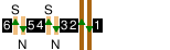
![[n6==4NS3==5s]](li/bak_oxc.gif) |
Cross-platform interchange with another line, which is also shown using the appropriate colour. The letters indicate the direction (e.g. N for northbound). In general tracks of other lines on the same level are shown, but not lines that are on a different level. |
![[-]](li/cenjruo.gif) |
A junction with other tracks on the same line. The other route is shown with these hollow lines, and will be described elsewhere on the page. |
![[-]](li/bak_cxj2.gif) |
A situation where tracks no longer exist. In this case, of the four lines (two for this route, two for the route branching off) only one of them is still present. |
![[-]](li/vicbsup.gif) |
The end of the line. |
![[-]](li/victmdn.gif) |
A tunnel mouth; trains heading down the page are entering the tunnel. Note that only significant tunnels are shown; short transitions between open and enclosed - particularly on the Circle Line - are excluded. |
![[-]](li/depbsup.gif) ![[-]](li/vicdepup.gif) |
A depot, accessible only from one end. Not all depots are shown. This is purely symbolic and does not indicate the layout of the depot. |
![[E2=/W1=]](li/cen_chl.gif) |
A station where this line is on two or more levels. The levels are shown from top to bottom in order; tracks that go above the current level are shown with a dashed line and those that go below with a dotted line. |
For those using browsers that do not display graphics, or with graphics disabled, station layouts are shown in the ALT tags:
 |
[W=WE=] | A simple station with a westbound island platform and an eastbound platform on the outside. The equals signs indicate platforms and the letters the tracks (here westbound on the left and eastbound on the right). |
 |
[n=NS=s] | Cross-platform interchange with another line; this line is in the middle (shown by capital letters) and the other on the outside (shown by lowercase letters). |
 |
[E4=2W] | A central platform, numbered 4 for eastbound trains and 2 for westbound trains. (The line colour here is that used for National Rail.) |
|
[OP] | This is an abbreviation for outside platforms on plain track, such as [=EW=]. |
|
[IP] | This is an abbreviation for a single island platform between tracks, such as [E=W]. |
|
[CP] | This is an abbreviation for separate platforms between two tracks, such as [E==W]. |
 |
[W=B=E] | B indicates a track signalled for both directions. |
 |
[T=NS=V] | T indicates a bay entered from the bottom, and V a bay entered from the top. |
|
[E2=/W1=] | A station where this line is on two or more levels. The levels are described from top to bottom in order, with the highest level on the left; there is a / between levels. |
|
| ||
 |
[=N =S] | If no platform numbers are given, they run from left to right starting at 1; equivalent to [=1N =2S]. |
 |
[N= S=+2] | If the numbers start at some other point, a suffix is added. So +2 means that the leftmost platform is number 3; equivalent to [N3= S4=]. |
 |
[=V] | Stations with only one platform default to no numbers. |
 |
[=sn=sn=SN= X] | An X suffix indicates that platforms should be counted from right to left; equivalent to [=6sn5=4sn3=2SN1=]. |
 |
[s==SN==n X+2] | The two can be combined; equivalent to [s6==5SN4==3n]. |
 |
[CP2] | The + may be omitted with these abbreviated forms; equivalent to [N3==4S]. |
 |
[OP#] | The # suffix means that numbers are not used; similarly, the # as a platform number means that platform is unnumbered; equivalent to [=#NS#=]. |
 |
[wew'A'='B'be'C'='D'V] | Unusual platform "numbers" are given in quotes. |
![[T=TT=4T =6ns=ns=t =b]](li/int_dsc3.gif) |
[w=ee3=5WW=E] | Where there is the occasional gap in otherwise sequential numbers, only the out-of-sequence numbers are shown; equivalent to [w1=2ee3=5WW6=7E]. |
|
| ||
|
[-] | This is used for all elements of the layout diagram other than stations. |
Significant work is involved in producing these diagrams. Until they are completed, the ALT tag forms are given instead.
 and
indicate that the station
has at least one lift or escalator respectively; the details can be found on the
separate
Lifts and Escalators page. At stations serving
lines which are at different depths, the relevant code is only used for those
lines where that mode of vertical transport is normally used to reach the
surface.
and
indicate that the station
has at least one lift or escalator respectively; the details can be found on the
separate
Lifts and Escalators page. At stations serving
lines which are at different depths, the relevant code is only used for those
lines where that mode of vertical transport is normally used to reach the
surface.
![[Z1]](li/zone1.gif) indicates that the
station lies in zone 1 of the London fare zone system.
The zone numbers run from 1 to 9;
special rules apply at Watford Junction ("zone W") and on Croydon Tramlink.
Where a station lies on a zonal boundary it will have two zones specified
thus
indicates that the
station lies in zone 1 of the London fare zone system.
The zone numbers run from 1 to 9;
special rules apply at Watford Junction ("zone W") and on Croydon Tramlink.
Where a station lies on a zonal boundary it will have two zones specified
thus ![[Z3/4]](li/zone34.gif) .
Stations outside the zonal system are indicated thus
.
Stations outside the zonal system are indicated thus
![[ZX]](li/zoneX.gif) .
.
This information is given for all open stations and for some closed stations. The presence or absence of an entry does not mean that the station closed before or after the introduction of the system.
This gives the name of the station (normally the present name or the name in use when the station was closed) or other feature. Renamings are not listed.
The name is adorned according to its current status:
| Heath Street | Station open on this line |
| (Heath Street) | Closed station |
| ((Heath Street)) | Former location of moved station |
| {Heath Street} | Station open on another line but not serving this one; includes open stations on lines under construction |
| {{Heath Street}} | Planned station or station under construction |
| {(Heath Street)} | Closed station planned to be reopened |
| [Heath Street Junction] | Feature other than a station |
Where new lines are being built single braces are used for open stations on the same alignment and double braces where a completely new part of the station is being built at an interchange.
 Depots
This lists the depot locations.
 Connections
This lists track connections with other lines (as opposed to passenger interchanges). Throughout the Guides the term "connection" is used for such a track connection, and "interchange" for a station where a passenger can change lines as part of a single journey.
 Rolling Stock
This lists the rolling stock currently used on the line, and restrictions on other stock. Note that tube stock is usually kept on a single line, and restrictions on a given stock applying to all lines will be listed under the line it normally runs on.
Tube Stock is named by the year of design (e.g. 1972 Tube Stock). Subsurface stock is named by its type letter - A, C, D, or S - possibly with a suffix. The A, C, and D stocks may have their year of design appended: A60/62, C69/77, and D78, though the informal term "C08" has also been used. The S stock was built in two sub-fleets intended to be run as 7-car and 8-car trains respectively and known as S7 and S8 (these have different seating arrangements). When a train from one sub-fleet is temporarily run with the other length, it is known as S7+1 or S8-1. A few S7 units were temporarily formed with 6 cars and were known as S6.
 Back to the CULG index.
 Back to the Rail
index.
Back to the Rail
index.
 Back to
Clive's home page.
Back to
Clive's home page.