
This page is a little collection of maps of the various tramway and light rail proposals for the Cambridge area.
First, the basic map of Cambridge used as a background for the other maps on this page:
(only a selection of secondary roads are shown). The blue area at top left is Oakington airfield and barracks, of which more later. Pedants should also note that the GER's spelling of village names did not always match the rest of the world's.
Cambridge did have a tram system for a few years at the beginning of the century:
The trams were horse-drawn and the system consisted of two simple routes - Senate House to Newmarket Road and Christ's College to the station - crossing at Hyde Park Corner. Despite this simplicity, there were loading gauge differences that meant that some trams were confined to one of the two routes! The system failed to make enough money to pay for the necessary road maintenance, and it was abandoned.
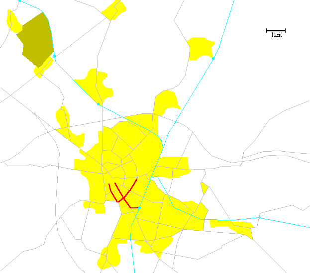
The next map shows proposals from the County Council in the mid-1980s.


The four branches would have served Park & Ride sites at Fenstanton, Milton, Fulbourn, and south of Trumpington and then all run into the middle of the city via Newmarket Road (which would imply either a lot of trams on the latter or rather infrequent service on the branches). The southwest route would have used the alignment of the old LNWR route to Bedford. If intermediate stops were proposed I have no record of them.
The scheme had a brief burst of publicity and died.
Recently Peter Dawe has been proposing a new city - Cambridge New Town, or C2 - to be built on the site of Oakington airfield and barracks. Part of this proposal would involve good transport links to and within the Cambridge area.
Peter has been kind enough to give me permission to publish a couple of the discussion maps for the Cambridge network, though without any explanations other than those I can deduce for myself.
The first diagram was a route diagram for three tram lines. I have attempted to work out where these would go, based only on the station names:

(the line colours were chosen by myself). This leads to quite a nice Beck-style map with an easily-remembered shape:

The lack of a station at Histon seems a little odd, and personally I would add one at the Science Park - on the other side of Milton Road - even though that would be close to the Park & Ride station. Others have suggested that one or two more stations could be added west of Fulbourn - either at Fulbourn West (the level crossing on the road to Teversham) or at Tesco on the new bypass.
The second map is a true map showing the various lines rather than proposed service patterns.

I generated a Beck-style map for this as well:

The same omissions from the stations seem a little odd. Furthermore it seems that the triangle serving the hospital is likely to merely add complexity to no good purpose. However, the most significant thing made clear by the diagram is that all the routes converge on the station and the route southwards. I suspect that the imbalance of 6 northern termini but only 2 southern ones needs a drastic revisit (note that the arrangement of routes south of Long Road is mine and is arbitrary).
Details of the various lines are:
It is important to note that Peter is not necessarily thinking of traditional tramways or light rail, but is still looking for appropriate technology - for example, the Parry People Mover has been suggested as a possibility. What will come of this, we will no doubt see.
 Back to the diagrams index.
Back to the Rail index.
Back to the diagrams index.
Back to the Rail index.
 Back to Clive's home page.