UK postcodes consist of two alphanumeric groups, separated by a space; for example N3 2QQ. The first group is called the outward code: it describes a small town, a district of a large town, or a rural area, such that the outward code is sufficient (with a few exceptions) to determine the sorting office that will deliver the mail. The second group is called the inward code: it represents a small group of addresses - from 70 houses down to a single business - that would always form part of the same delivery round. Typically the inward code covers one side of a short street, or a natural section of a longer one.
The outward code consists of an area and a district; in 8 cases the district is then divided into sub-districts. The UK (here including the independent authorities) is divided into 121 areas and 2900 districts and sub-districts. Each area is represented by a one- or two-letter code, and the district by a number from 0 to 99; sub-districts have a single letter. For example, N23 is district 23 of area N, and W1A is sub-district A of district 1 of area W.
The inward code consists of a sector and a group. The sector is indicated by a digit, and the group by two letters; for example, 2QQ is group QQ of sector 2. Only 20 letters are used in groups (C, I, K, M, O, and V are not used), and so there are 400 groups in each sector and 4000 groups in each district or sub-district.
This table gives the number of postal areas and districts in each region of the UK. 8 of the London Postal districts are split into a total of 63 sub-districts.
| Region | Areas | Districts | Outward codes |
|---|---|---|---|
| Total | 124 | 2845 | 2900 |
| England | 99 | 2102 | 2157 |
| London Postal Areas | 8 | 124 | 179 |
| Outer London | 10 | 142 | 142 |
| Rest of England | 81 | 1836 | 1836 |
| Scotland | 16 | 453 | 453 |
| Wales | 5 | 185 | 185 |
| Northern Ireland | 1 | 80 | 80 |
| Independent | 3 | 25 | 25 |
The next table lists the 124 postal areas.
| Code | Location | |
|---|---|---|
| S | AB | Aberdeen |
| rE | AL | Saint Albans |
| rE | B | Birmingham |
| rE | BA | Bath |
| rE | BB | Blackburn |
| rE | BD | Bradford |
| rE | BH | Bournemouth |
| rE | BL | Bolton |
| rE | BN | Brighton |
| OL | BR | Bromley |
| rE | BS | Bristol |
| NI | BT | Belfast |
| rE | CA | Carlisle |
| rE | CB | Cambridge |
| W | CF | Cardiff |
| rE | CH | Chester |
| rE | CM | Chelmsford |
| rE | CO | Colchester |
| OL | CR | Croydon |
| rE | CT | Canterbury |
| rE | CV | Coventry |
| rE | CW | Crewe |
| rE | DA | Dartford |
| S | DD | Dundee |
| rE | DE | Derby |
| S | DG | Dumfries and Galloway |
| rE | DH | Durham |
| rE | DL | Darlington |
| rE | DN | Doncaster |
| rE | DT | Dorchester |
| rE | DY | Dudley |
| LP | E | London east |
| LP | EC | London east central |
| S | EH | Edinburgh |
| OL | EN | Enfield |
| rE | EX | Exeter |
| S | FK | Falkirk |
| rE | FY | Fylde (Blackpool) |
| S | G | Glasgow |
| rE | GL | Gloucester |
| rE | GU | Guildford |
| Ind | GY | Guernsey |
| OL | HA | Harrow |
| rE | HD | Huddersfield |
| rE | HG | Harrogate |
| rE | HP | Hemel Hempstead |
| rE | HR | Hereford |
| S | HS | Outer Hebrides |
| rE | HU | Hull |
| rE | HX | Halifax |
| OL | IG | Ilford and Barking |
| Ind | IM | Isle of Man |
| rE | IP | Ipswich |
| S | IV | Inverness |
| Ind | JE | Jersey |
| S | KA | Kilmarnock and Ayr |
| OL | KT | Kingston-upon-Thames |
| S | KW | Kirkwall |
| S | KY | Kirkcaldy |
| rE | L | Liverpool |
| rE | LA | Lancaster |
| W | LD | Llandrindod Wells |
| rE | LE | Leicester |
| W | LL | Llandudno |
| rE | LN | Lincoln |
| rE | LS | Leeds |
| rE | LU | Luton |
| rE | M | Manchester |
| rE | ME | Medway |
| rE | MK | Milton Keynes |
| S | ML | Motherwell |
| LP | N | London north |
| rE | NE | Newcastle-upon-Tyne |
| rE | NG | Nottingham |
| rE | NN | Northampton |
| W | NP | Newport Gwent |
| rE | NR | Norwich |
| LP | NW | London northwest |
| rE | OL | Oldham |
| rE | OX | Oxford |
| S | PA | Paisley |
| rE | PE | Peterborough |
| S | PH | Perth |
| rE | PL | Plymouth |
| rE | PO | Portsmouth |
| rE | PR | Preston |
| rE | RG | Reading |
| OL | RH | Redhill |
| OL | RM | Romford |
| rE | S | Sheffield |
| W | SA | Swansea |
| LP | SE | London southeast |
| rE | SG | Stevenage |
| rE | SK | Stockport |
| rE | SL | Slough |
| OL | SM | Sutton and Merton |
| rE | SN | Swindon |
| rE | SO | Southampton |
| rE | SP | Salisbury plain |
| rE | SR | Sunderland |
| rE | SS | Southend-on-Sea |
| rE | ST | Stoke-on-Trent |
| LP | SW | London southwest |
| rE | SY | Shrewsbury |
| rE | TA | Taunton |
| S | TD | Tweeddale |
| rE | TF | Telford |
| rE | TN | Tonbridge |
| rE | TQ | Torquay |
| rE | TR | Truro |
| rE | TS | Teeside |
| rE | TW | Twickenham |
| OL | UB | Uxbridge |
| LP | W | London west |
| rE | WA | Warrington |
| LP | WC | London west central |
| rE | WD | Watford |
| rE | WF | Wakefield |
| rE | WN | Wigan |
| rE | WR | Worcester |
| rE | WS | Walsall |
| rE | WV | Wolverhampton |
| rE | YO | York |
| S | ZE | Shetlands |
The codes in the left column give the region this code is allocated to in the previous table:
| LP | London postal areas |
|---|---|
| OL | Outer London |
| rE | Rest of England |
| S | Scotland |
| W | Wales |
| NI | Northern Ireland |
| Ind | Independent authorities |
The London postal areas pre-date the introduction of postcodes, and it was found that some districts would require more than 4000 groups. These were therefore divided into sub-districts by adding a letter to the outward code. There are 12 different letters; there is no obvious logic behind the choices made.
| District | Sub-districts | |||||||||||
|---|---|---|---|---|---|---|---|---|---|---|---|---|
| EC1 | A | B | M | N | P | R | V | Y | ||||
| EC2 | A | B | M | N | P | R | V | Y | ||||
| EC3 | A | B | M | N | P | R | V | |||||
| EC4 | A | B | M | N | P | R | V | Y | ||||
| SW1 | A | E | H | P | V | W | X | Y | ||||
| W1 | A | E | H | M | N | P | R | V | X | Y | ||
| WC1 | A | B | E | H | N | R | V | X | ||||
| WC2 | A | B | E | H | N | R | ||||||
Finally, this table lists all 2845 postal districts.
| To be written |
|---|
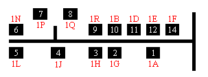
The delivery point suffix or walk sort code is a two character code that is used only in bar codes and uniquely identify each address within a single postcode. The code consists of a digit (from 1 to 4) followed by a letter from the set of 20 used in inward codes.
The allocation of codes to addresses is not particularly obvious.
For example, here is an actual street of 13 houses (shown stylized):
A number of special codes have been created for various purposes.
 UK Postcodes or
the Postcodes index.
UK Postcodes or
the Postcodes index.
 Back to Clive's home page.